Isle of Wight by itself United Kingdom England 1760 Bellin detailed map
Brian DiMambro- Antiquarian Books, Maps & Prints


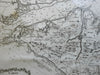

Carte de l'Isle de Wight.
(Europe, British Isles, United Kingdom, England, Isle of Wight, Newport, Yarmouth, West Cowes, East Cowes).
Issued 1760, Paris by Bellin.
Mid 18th century engraved map with a pleasing, strong impression.
Decorative and uncommon map with cartouche, fleur-de-lys and rhumb lines.
Nice looking example, pleasing age patina, any minor age flaws easy to overlook or forgive.
Original fold line as issued.
Sheet measures c. 12 3/4" H x 18" W.
Engraved area measures c. 9" H x 14" W.
Cartographic Reference(s):.
Tooley's Dictionary of Mapmakers, vol.1.
[R22956].