New Zealand 1774 by Capt. Cook & Hawkesworth 1st French edition important map
Brian DiMambro- Antiquarian Books, Maps & Prints
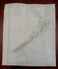
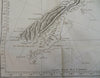
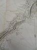
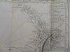
Carte de la Nle. Zelande visitee en 1769 et 1770 par le Lieutenant J. Cook, Commandant de L'Endeavour Vasseau de se Majeste.
(Old Maps, 18th Century Maps, Oceania, New Zealand, North Island, South Island, Cook Strait).
Issued 1774, Paris by Hawkesworth. Map by Benard.
Important 18th century engraved map, the first French edition of 1774 taken from the 1773 English version. The first complete map of the islands, and the single most important map of these islands. The charting done by Cook confirmed they were separate islands and not part of the mysterious Southern Continent.
Extensive tracks, sounding depths and interior terrain. Marks the earliest encounter between Maori and Europeans.
Nice looking example, pleasing age patina, overall very clean, any minor age flaws easy to overlook or forgive.
Original fold lines as issued.
Sheet measures c. 20 1/2" H x 17" W.
Engraved area measures c. 19 1/4" H x 15" W.
Cartographic Reference(s):.
Tooley's Dictionary of Mapmakers, vol. 2.
[R29228].