British Columbia Vancouver Island Western Canada Caledonia c. 1856-72 Weller map
Brian DiMambro- Antiquarian Books, Maps & Prints

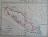
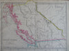
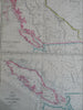
British Columbia (New Caledonia) - Vancouver Island.
(Old Maps, 19th Century Maps, North Americana, Canada, Western Canada, British Columbia, Vancouver Island).
Issued c. 1856-72, London by Edward Weller for the Weekly Dispatch Atlas.
Mid 19th century lithographed map with original outline hand color.
A relatively uncommon/ scarce map which was among maps issued in weekly installments for many years by this firm.
Typical signs of time and wear, a soft old crease line down the middle which is easy to overlook.
Sheet Measures c. 13 1/2" H x 18 1/4" W.
Printed Area Measures c. 12" H x 17" W.
Cartographic Reference(s):
Tooley's Dictionary of Mapmakers, vol. 4.
[R30349].