Geography geographical pocket atlas 1751 unique binding 17 Vaugondy world maps
Brian DiMambro- Antiquarian Books, Maps & Prints


[Geography, French geographies, pocket atlases, mid-18th Century Maps].
Short video captures condition much better than words. Please watch prior to purchase to ensure a clear understanding of the book.
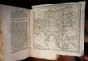
Methode Abregee et Facile Pour Apprendre La Geographie.
Published 1751, Paris by Brocas.
17 folding maps, 552 pages.
Maps include world in double hemispheres, the continents and numerous regional maps of the world. Essentially a small mid-18th century pocket atlas.
Period binder's paste boards, temporary binding most often discarded when bound in leather.
All text block edges deckled and untrimmed as issued.
Interior remains mostly clean and free of spotting, couple leaves with old/ early ink staining (likely from quill pen). All maps clean and nice looking.
Book measures: 7 1/2" H X 4 1/4" W.
[V1988].