Kingdom of Greece Balkan Peninsula Morea Crete Rhodes 1845 Greenleaf Map
Brian DiMambro- Antiquarian Books, Maps & Prints
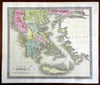
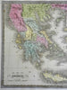
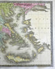
Greece.
(Europe, Balkans, Kingdom of Greece, Crete, Morea, Thessaly, Epirus).
Issued c. 1845, Brattleboro, Vermont by Jeremiah Greenleaf.
Uncommon mid 19th century engraved map with original hand color.
Nice looking example, pleasing age patina, any minor age flaws easy to overlook or forgive.
Sheet Measures c. 12" H x 14 1/4" W.
Engraved Area Measures c. 10 5/8" H x 12 1/2" W.
Cartographic Reference(s):
Tooley's Dictionary of Mapmakers, vol. 2.
[PL45].