Russian Empire Europe 1864 lithographed map hand color
Brian DiMambro- Antiquarian Books, Maps & Prints
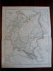
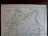
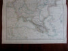
Russia in Europe by G. H. Swanston.
(Europe, Russia, Poland, Finland, Crimea, Black Sea, Caspian Sea)
Issued Edinburgh, London, & Dublin, ca. 1864 by A. Fullarton & Co.
Fine and uncommon mid-19th century color lithographed map. Backed long ago with thin linen, greatly enhancing the strength of the sheet.
Map remains well preserved. Some light age wear or surface spotting/ soiling which is visible within the scan, overall visually appealing
Paper and image remains overall clean & sound.
Original fold line as issued.
Sheet measures c. 23 1/4" H x 18 1/2" W.
Printed area measures c. 20 3/4" H x 16 3/8" W
Tooleys Dictionary of Mapmakers , v. 2, p. 123*
[R20706]