Sweden Norway Finland Russian Travel Guide 1915 WWI era illustrated book 6 maps
Sweden Norway Finland Russian Travel Guide 1915 WWI era illustrated book 6 maps Sweden Norway Finland Russian Travel Guide 1915 WWI era illustrated book 6 maps Sweden Norway Finland Russian Travel Guide 1915 WWI era illustrated book 6 maps Sweden Norway Finland Russian Travel Guide 1915 WWI era illustrated book 6 maps Sweden Norway Finland Russian Travel Guide 1915 WWI era illustrated book 6 maps Sweden Norway Finland Russian Travel Guide 1915 WWI era illustrated book 6 maps Sweden Norway Finland Russian Travel Guide 1915 WWI era illustrated book 6 maps Sweden Norway Finland Russian Travel Guide 1915 WWI era illustrated book 6 maps Sweden Norway Finland Russian Travel Guide 1915 WWI era illustrated book 6 maps Sweden Norway Finland Russian Travel Guide 1915 WWI era illustrated book 6 maps Sweden Norway Finland Russian Travel Guide 1915 WWI era illustrated book 6 maps Sweden Norway Finland Russian Travel Guide 1915 WWI era illustrated book 6 maps Sweden Norway Finland Russian Travel Guide 1915 WWI era illustrated book 6 maps Sweden Norway Finland Russian Travel Guide 1915 WWI era illustrated book 6 maps Sweden Norway Finland Russian Travel Guide 1915 WWI era illustrated book 6 maps Sweden Norway Finland Russian Travel Guide 1915 WWI era illustrated book 6 maps Sweden Norway Finland Russian Travel Guide 1915 WWI era illustrated book 6 maps Sweden Norway Finland Russian Travel Guide 1915 WWI era illustrated book 6 maps Sweden Norway Finland Russian Travel Guide 1915 WWI era illustrated book 6 maps Sweden Norway Finland Russian Travel Guide 1915 WWI era illustrated book 6 maps Sweden Norway Finland Russian Travel Guide 1915 WWI era illustrated book 6 maps
$ 395.00

(Old Books, 20th Century Books, Travel, Tourism, Scandinavia, Finland, Sweden, Norway, Illustrated Books, Books with Maps).

Finland, Sweden, and Norway Illustrated Practical Guide.
Published 1915, Petrograd, Russian Empire by Moskvich.
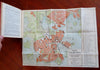
296 pages. Text in Russian. Illustrated throughout w/ many b&w photographs & seven color lithographed folding maps (one is a small oblong profile view of a tall mast ship going through a lock canal system- not shown).

Publisher's cloth binding, gilt title lettering. Very scarce guide book in any condition.

Book is physically old and shows some signs of handling and time. Book is not new or in "new" condition.

Binding age worn with some old discoloration (likely water stains), mostly light or inoffensive signs of handling and time but nothing severe or unsightly, book remains overall attractive as an object.

Paper is gently toned, still clean, mildly shaken, sound internally. A couple large folding maps have tears or old paper repairs on reverse.

Still attractive on the shelf. The book displays a pleasing and unique age patina and is in overall nice antiquarian condition, any age flaws which may be present seem easy to overlook or forgive. 

Please review photos for more detail showing how this rare guide book survives. The asking price reflects the condition based on our examination and 35+ years full time exposure to antiquarian books, maps and printed ephemera of all types and genres. Flaws seen and/ or described have been taken into account.

Book Measures c. 6 3/4" H x 4 1/2" W.

[B10057].