Eastern Europe Scandinavia Russia Poland Ukraine 1889 Petermann HUGE 6 sheet map
Brian DiMambro- Antiquarian Books, Maps & Prints
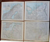
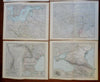
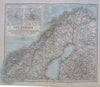
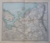
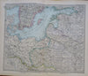
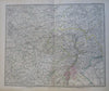
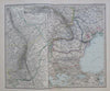
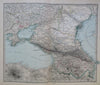
Ost-Europa in 6 Blattern, Enthaltend Norwegen, Schweden, Russland, Kaukasien, und die Turkei.
(Old Maps, 19th Century Maps, Europe, Scandinavia, Sweden, Norway, Denmark, Russian Empire, Finland, Baltic States, Poland, Ukraine, Crimea, Caucasus).
Issued 1889 Gotha by Justus Perthes for Stieler. Map by Petermann.
A large and very detailed 19th century engraved 6 multi-sheet map with original outline hand color.
Stieler maps went through continual revisions. Thus, for any specific Stieler map such as this one, there are often numerous variant issues with varying details.
Nice looking example, clean, pleasing age patina, any minor age flaws easy to overlook or forgive.
Map consists of 6 sheets which form a wall size map of the era. Please see photos.
Original center folds as issued.
Sheet Measures c. 13 3/4" H x 17" W.
Cartographic Reference(s):
Tooley's Dictionary of Mapmakers, vol. 4.
[R29510].