England 1654 Mercia East Anglia South Northumbria Sanson fine antique large map
Brian DiMambro- Antiquarian Books, Maps & Prints
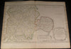


Anciens Royaume de Mercie, et East-Angles our sont les Comtes, ou Shiries de Chester, Darby, Nottingham, Lincolne, Rutland, Leicester, Stafford, Shrop-Shire, Hereford, Worcester, Warwick, Northampton, Huntington, Bedford, Buckingham, Oxford, et Glocester en Mercie: Cambridge, Norfolk, et Suffolk en East-Angles
(Eastern England)
Issued 1654, Paris by Sanson
Fine and uncommon old color map of Mercia and East Anglia, with Derby, Chester, Warwick, Worcester, Oxford, Cambridge, Nottingham, Hereford, and Buckingham.
Delightful large cartouche featuring caryatids, a small ornate distance scale beside it.
A picture is worth a thousand words. The photos are a major part of the item description. Please examine them closely, as what you see is what we will send you.
[note: we grade conservatively and always seek to disclose any noteworthy flaws.].
Map remains well preserved. Some light age wear or surface spotting/ soiling which is visible within the scan, side margins narrow as issued and now age browned, printed area very clean, a nice detailed large old map.
Paper and image remains overall clean & sound. Old maps & prints often display small minor repairs on the back, could have uneven blank margins, might have extraneous fold-lines or other small minor age flaws which do not detract from the visual appeal or value. Condition is carefully considered in arriving at our price.
Great antique map entirely worthy of hanging for display.
A depiction captured in a manner entirely unique to this era.
Sheet measures c. 17 7/8" H x 23 5/8" W.
Printed area measures c. 14 3/8" H x 22 7/8" W
Original fold line as issued.
Tooleys Dictionary of Mapmakers , v. 4, p. 102
[R1641]