Netherlands 7 Provinces c. 1780 Bowen folio Holland lovely color antique map
Brian DiMambro- Antiquarian Books, Maps & Prints
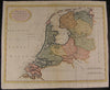
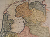
The Seven United Provinces Accurately Drawn from the most Approved Modern Maps and Charts
issued London, c. 1780 by T. Bowen
Beautiful, well-preserved late 18th century engraved map of the Netherlands and its seven provinces.
Beautifully hand colored.
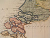
In near VG, well-preserved condition, some extraneous vertical fold-lines as typical which do not detract visually
Sheet measures c. 17" W x 14" H.
Printed area c. 16 1/4" W x 12 1/2" H.
Folio.
Tooleys Dictionary of Mapmakers , vol. 1, p. 176
R611