Portoferraio Elba island Italy Italia detailed city plan 1760 Bellin map
Brian DiMambro- Antiquarian Books, Maps & Prints
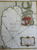
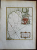
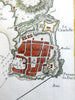
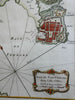
Plan de Port Ferrare dans l'Isle d'Elbe.
(Europe, Italy, Tuscany, Elba, Portoferraio, Citadel, Fortifications, Port).
Issued 1760, Paris by Bellin. Engraved by Croisey.
Mid 18th century engraved map with a pleasing, strong impression. Beautiful hand color enhances the visual appeal.
Nice looking example, pleasing age patina, any minor age flaws easy to overlook or forgive.
Sheet measures c. 12 3/4" H x 9 1/4" W.
Engraved area measures c. 9" H x 7 1/4" W.
Cartographic Reference(s):.
Tooley's Dictionary of Mapmakers, vol.1.
[R23305].