Annis Squam Ipswich Bay Massachusetts 1827 Blunt antique nautical map hand color
Brian DiMambro -Historical Investments

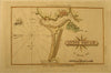
Annis Squam
(North Eastern United States- New England Coastal map)
Issued 1827, NY by Edm. & Geo. Blunt
Fine and uncommon early 19th century coastal map of this important and historic region. With lovely hand color. Nice looking old American produced small nautical map which dates from the early part of the 1800's.
A picture is worth a thousand words. The photos are a major part of the item description. Please examine them closely, as what you see is what we will send you.
[note: we grade conservatively and always seek to disclose any noteworthy flaws.].
Map remains well preserved with a nice age patina. Some light age wear or surface spotting/ soiling which is visible within the scan. Normal minor age wrinkling to paper surface.
Paper and image remains overall clean & sound. Old maps & prints often display small minor repairs on the back, could have uneven blank margins, might have extraneous fold-lines or other small minor age flaws which do not detract from the visual appeal or value. Condition is carefully considered in arriving at our price.
Great old vintage antique map entirely worthy of hanging for display.
A depiction captured in a manner entirely unique to this era.
Sheet measures c. 5" H x 8 1/4 " W.
Printed area measures c. 4" H x 6 3/4 " W
Tooleys
Dictionary of Mapmakers
, v. 1
Campbell,
Bibliography of American Coast Pilot
, p.109 (#13)
[R6306]