Lerida Lleida Catalonia Spain 1707 town & Castle war 1740 engraved antique map
Brian DiMambro -Historical Investments
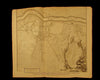
Plan of the Town and Castle of Lerida, with the Approaches made before it by the French 7 Spanish Armies under the command of the Duke of Orleans during the Siege began Oct. 2, 1707
(Catalonia region- Spain)
Issued c.1730-40, London for Tindal & Rapin
Engraved by J. Basire
Fine, appealing and uncommon old copper engraved folio sheet map.
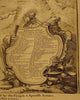
Decorative large Explanation cartouche at lower right contains a long list of almost 50 specific features which are identified on the map. Segre River runs across the top, terrain and topographical details include various early fortifications now long since removed.
As originally issued long ago, an actual antique/ vintage printed sheet of paper, not a modern copy or reprint. The paper sheet could show various minor signs of age, but if we are offering it for sale, you can be 100% certain it is entirely worthy of ownership by even the most discerning collector or dealer.
A picture is worth a thousand words. The scan is a major part of the item description. Please examine it closely, as what you see is what we will send you.
[note: we grade conservatively and always seek to disclose any noteworthy flaws.].
Sheet remains well preserved, keeping in mind it is not modern or new, so minor flaws to paper unworthy of specific mention are sometimes to be expected. Some light age wear or surface spotting/ soiling, all of which is hopefully visible within the zoomable scan.
Note the top blank margin edge is trimmed narrow just barely grazing into the engraved area- readily framable none the less.
Paper and image remains overall clean & sound. Old maps & prints often display small minor repairs on the back, could have uneven blank margins, might have extraneous fold-lines or other small minor age flaws which do not detract from the visual appeal or value. Condition is carefully considered in arriving at our price.
Great old vintage antique map entirely worthy of hanging for display.
A cartographic depiction captured in a manner entirely unique to this era.
Sheet measures c. 15 1/4" H x 21" W.
Printed area measures c. 14" H x 18 1/4" W
[R7025]