London Bayswater Notting Hill Kensal Green Shepherds Bush c.1860 Weller map
AntiqueMapsPrints.com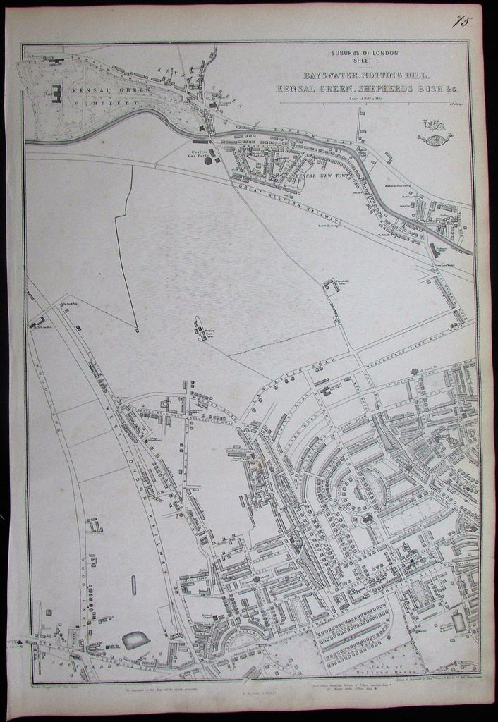
Suburbs of London
Sheet I.
Bayswater, Notting Hill,
Kensal Green, Shepherds Bush &c.
(London, England, United Kingdom)
Issued London, c. 1856-70 by Weller.
Fine, detailed and uncommon mid 19th century folio sheet lithographed map.
As originally issued long ago, an actual antique/ vintage printed sheet of paper, not a modern copy or reprint of an old map. The paper will show various minor signs of age, but if we are offering it for sale, you can be certain it is entirely worthy of ownership by even the most discerning collector or dealer.
Sheet remains well preserved, keeping in mind it is not modern or new, so minor flaws and signs of age to paper unworthy of specific mention are normal and to be expected. Overall appearance is hopefully captured within the images.
Great old antique map entirely worthy of hanging for display, gift-giving, resale, etc.
A cartographic depiction captured in a manner entirely unique to this era.
Sheet measures c. 19" H x 13 1/4" W.
Printed area measures c. 17" H x 12" W.
Tooley's
Dictionary of Mapmakers
, Vol IV, p. 370
[R9341]
Paper and image remains overall clean & sound. Old maps & prints often display small minor repairs on the back, could have uneven blank margins, might have extraneous fold-lines or other small minor age flaws which do not detract from the visual appeal or value. Condition is carefully considered in arriving at our price.
A picture is worth a thousand words. The images are a major part of the item description. Please examine closely, what you see is what we will send you.
[note: we grade conservatively and always seek to disclose any noteworthy flaws.].